search
location_on
Choose your country:
Austria
Belgium
Czech Republic
Denmark
Finland
France
Germany
Greece
Hungary
Ireland
Italy
Netherlands
Norway
Poland
Portugal
Spain
Sweden
Switzerland
United Kingdom
filter_list
home
Categories
No Category filter available
Price
Discount
+20%
+30%
+40%
+50%
+60%
+80%
Brands
7H SEVENON
A.B.S.
ABAKUS
AccuCell
ACKOJA
AGFAPHOTO
AGI
AIC
AJUSA
AKS DASIS
Al-Ko
ALCO
ALKAR
Andersson
Apc
Apollo's Hegemony
April
AS-PL
ASG
ASHIKA
ATE
Aurender
AUTOFREN SEINSA
AVERY
Avery Dennison
aXpel
B2B Partner
Bartscher
Becker
Beta
Bf
BGA
BLUE PRINT
BlueOptics
Bosch
BREMBO
BREMI
Broadcom
brother
BUDWEG CALIPER
Buff
Caglificio Clerici
CAME
Canon
CASCO
Champion
CHERRY
CONTINENTAL/VDO
ContiTech
CORTECO
Cotta
Creon
crinos
CS Germany
CTR
Daikin
daybays
Dell
DELPHI
Dema
DENCKERMANN
DENSO
DEWALT
DIEDERICHS
Dornbracht
Dr.Motor Automotive
DT Spare Parts
Dæhlie
Easyprint
Ecler
EG S.p.A.
ELRING
ELSTOCK
EPS
Epson
ERA
ERA Benelux
ERNST
ESEN SKV
EURAST
EUROTEC
Evolis
Exenthia
extra sas di verducci s.&c.
Extreme Networks
f.becker
FACET
FAG
FAI AutoParts
FAST
FEBEST
Febi
FEBI BILSTEIN
Filmar
Filmer
FILTRON
FRENKIT
FRIESEN
Fujitsu
Fujitsu Technology Solutions
Gardena
GATES
GEBE
Gedore
Gerdmans
Gigao
Godet
GOETZE ENGINE
GRAF
Green2Print
Grohe
GSP
Haier
Hbm
Heimeier
HELLA
Hendi
HENGST FILTER
HEPU
HERTH+BUSS JAKOPARTS
Hikoki
Hirudoid
Hivital Foods
HJS
HMF
Home Affaire
horizon lab company
Hp
HP Enterprise
Hpe Aruba
Huawei
HYGOSTAR
INA
Infowerk
IPAE-PROGARDEN
JAPANPARTS
JAPKO
Jason
Jason Cosmetics
Joop!
Judo
kaiserkraft
KAMOKA
KASE
KB Global
Kensington
Kicloutou
KK Verpackungen
KNECHT
KOLBENSCHMIDT
Konica Minolta
Kyocera
KYOCERA MITA
L.Brador
Lancom
Lavor
LEDVANCE
LEMFÖRDER
Lenovo
LESJÖFORS
Lexmark
LightInthebox
long life
Louis Tellier
LPR
MAGNETI MARELLI
MAHLE
Makita
MANN-FILTER
MAPCO
MAS
MASTER-SPORT
MAUL
MAXGEAR
MEAT & DORIA
Meat&Doria
Medion
Mellanox
Mellanox Technologies
Metabo
Metalcaucho
METELLI
METZGER
MEYLE
MFT
Microsoft
Midea
MikroTik
Mitsubishi
MOBILETRON
Monouso
MOOG
Nabbi
Narwal
NATURANDO
Netgear
NGK
Niehoff Sitzmöbel
NIPPARTS
NISSENS
NOW,NOW Foods
NOW,NOW Foods,NOW,NOW Foods
Nuova Algis
Nutras
NVIDIA
OBV
ODLO
OKI
Olympus
OPTIMAL
ORIGINAL IMPERIUM
Panasonic
Panzerglass
Papstar
PELA
PETERS ENNEPETAL
Philips
PIERBURG
Pipercross
Plantis
Pny
Powertek
Powerware
Powery
PRASCO
Pressalit
Print24
Prodotti Megaclima
PURFLUX
PURLINE
Qnap
QUARO
QUINTON HAZELL
Rapid
Razer
Realpower
REDFAIR
REGLOO
Reinz
Relafit
Rennsteig
Rewatec
Ricoh
Rothenberger
ROWE
S-Tr
SACHS
SAMPA
Samsung
SCHRADER
Seagate
Servotec
SIDEM
SilverStone
Sit & More
SKF
SNR
Sony
SPIDAN
SPRITE SHOWERS
SWAG
SWF
SWS
SWSTAHL
Tadiran
Tcl
Technaxx
Tecnomat
TEDGUM
Tiera
TiP
TRISCAN
TRW
TRW Engine Component
TYC
Ubbink
Ubiquiti
UFI
Ugreen
ulsonix
Umara
V-Tac
VALEO
VAN WEZEL
Varta
VEGAZ
Vellight
VEMO
VICTOR REINZ
Vortice
Weather Report
WeightWorld
Whistler
Xerox
Yamaha
Yato
Zigzag
ZIMMERMANN
Zyxel
Merchants
Ackermann.ch
Afarma.it
Agrieuro.com
Agrieuro.de
Agrieuro.fr
Anticafarmaciaorlandi.it
Aqua-techniques.fr
AUTODOC
axpel-oneforall.ch
B2b-partner.pl
BAUR Versand
baur.de
BENZ24
Billigteknik.se
Bli-god.no
Braasport.no
Chip7.pt
Chip7.pt
Clima-inverter.com
Climamarket.com
Climatuo.it
Curaenatura.com
Cyberphoto.se
Dema-france.com
Desivero.com
Digit-photo.com
Distripool.fr
Drmax.it
E-gate.gr
Ecosupplements.fi
Ecosupplements.nl
Elektroimportoren.no
Epto.it
Euronics.it
Expondo.cz
Farmaciasoccavo.it
Fjellsport.no
Futunatura.es
Gerdmans.fi
Gm-termoidraulica.it
Guedo-outillage.fr
Hbm-machines.com
Hektapatur.no
Jelmoli-shop.ch
Kaiserkraft.ch
Kaiserkraft.pt
Kamody.fr
kfzteile24.de
Kfzteile24.de
Kicloutou.fr
Klockmagasinet.com
Kontorsgiganten.se
Lauf-bar.de
Liberotech.it
Linfafarmacie.it
Lomax.dk
Ltt-versand.de
Lyreco.se
Manutan
Maxgaming.no
Maxgaming.se
Med24.no
Megaclima.it
Metro.de
Mielearredo.com
motointegrator
Motointegrator.de
Motointegrator.es
Motointegrator.fr
Motointegrator.it
Motointegrator.nl
motointegrator.pt
Netonnet.no
Nutritienda.com
Nutritienda.com
Obadis.com
Obadis.com
Pccomponentes.pt
Polsinelli.it
Prezzoforte.it
Price1
Promofarma.com
Radiopopular.pt
Refurbed.se
Secret Sales
Sferaufficio.com
Skybad FR
Skybad.de
Skybad.de
Skybad.de
slewo.com
Soundgarden.no
Tacticalstore.se
Tecnomat.it
Tonerecartucceonline.it
Unieuro.it
Universal.at
Verktygsboden.se
Vpd.fi
Woodbrass.com
www.lightinthebox.com/it
Zeproc AS
Brand: All
Merchant: All
Products: 5,743
Sort by:
sort
RELEVANCE
RELEVANCE
PRICE: Low To High
PRICE: High To Low
DELL
Dell Precision 5570 i7-12800H 15.6" 8 GB 128 GB SSD WUXGA Bakgrundsbelyst tangentbord RTX A2000 8 GB Win 11 Pro BE
12,933.99 SEK
Refurbed.se
local_shipping
Free
DETAIL
DELL
Dell Precision 7560 i7-11850H 15.6" 32 GB 1 TB SSD FHD RTX A4000 Bakgrundsbelyst tangentbord Webcam Win 11 Pro FR
12,908.95 SEK
Refurbed.se
local_shipping
Free
DETAIL
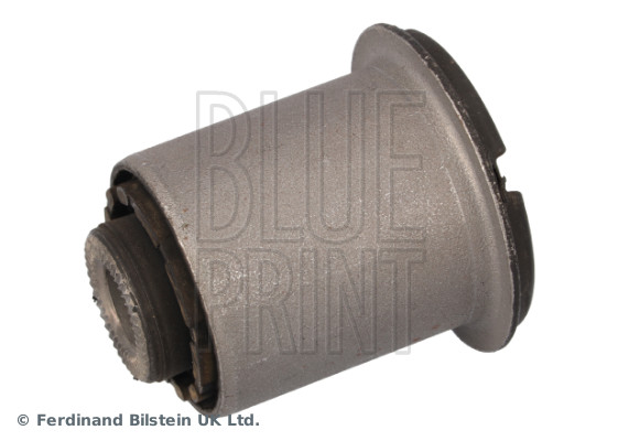
BLUE PRINT
BLUE PRINT Lagerung, Lenker ADBP800617 vorne rechts links 38mm für HYUNDAI KIA 54551-A4000
9.69 €
kfzteile24.de
local_shipping
6.9 €
DETAIL
Febi
Radnabe FEBI BILSTEIN 45000
58.84 €
Motointegrator.de
local_shipping
6.95 €
DETAIL
DELL
Dell Precision 7560 i9-11950H 15.6" 8 GB 2 TB SSD FHD Bakgrundsbelyst tangentbord RTX A2000 Win 11 Pro CZ
15,887.37 SEK
Refurbed.se
local_shipping
Free
DETAIL
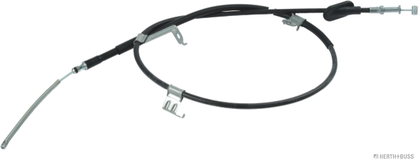
HERTH+BUSS JAKOPARTS
HERTH+BUSS JAKOPARTS Seilzug, Feststellbremse J3937017 rechts für SUBARU 26051-AG000
28.91 €
kfzteile24.de
local_shipping
6.9 €
DETAIL
ABAKUS
ABAKUS Nebelschlussleuchte 221-4008R-UE rechts ohne Glühlampe für HYUNDAI 92406-A6000 92406A6000 92406A5000
60.54 €
kfzteile24.de
local_shipping
6.9 €
DETAIL
APC
APC E3SUPS15K3IB1 gruppo di continuità (UPS) Doppia conversione (online) 15 kVA 15000 W
8,353.83 €
Price1
local_shipping
Free
DETAIL
DELL
Dell Precision 7560 i9-11950H 15.6" 24 GB 1 TB SSD FHD Bakgrundsbelyst tangentbord RTX A2000 Win 11 Pro ES
15,645.13 SEK
Refurbed.se
local_shipping
Free
DETAIL
DELL
Dell Precision 5570 i7-12800H 15.6" 8 GB 256 GB SSD WUXGA FP Bakgrundsbelyst tangentbord RTX A2000 8 GB Win 11 Pro FR
12,252.54 SEK
Refurbed.se
local_shipping
Free
DETAIL
DELL
Dell Precision 5570 i7-12800H 15.6" 8 GB 2 TB SSD WUXGA Bakgrundsbelyst tangentbord RTX A2000 8 GB Win 11 Pro IT
15,478.44 SEK
Refurbed.se
local_shipping
Free
DETAIL
Haier
HAIER Climatizzatore Trial Split Expert Black Wifi 12000+12000+15000 Btu Inverter R32 A++ 4u75s2sr5fa
3,601.0 €
Gm-termoidraulica.it
local_shipping
Free
DETAIL
DELL
Dell Precision 7560 i9-11950H 15.6" 24 GB 2 TB SSD FHD Bakgrundsbelyst tangentbord RTX A2000 Win 11 Pro PL
16,069.16 SEK
Refurbed.se
local_shipping
Free
DETAIL
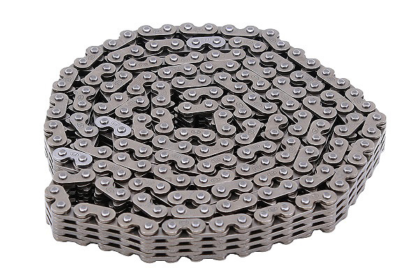
INA
INA Steuerkette 553 0328 10 für HYUNDAI KIA (BEIJING) 2432125000 24321-25000
61.69 €
kfzteile24.de
local_shipping
6.9 €
DETAIL
HP
HP ZBook Fury 15 G8 i7-11850H 15.6" 16 GB 512 GB SSD RTX A2000 FHD Win 11 Pro DE
13,924.99 SEK
Refurbed.se
local_shipping
Free
DETAIL
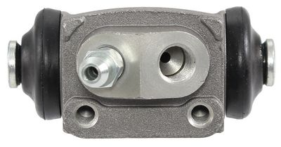
A.B.S.
A.B.S. Radbremszylinder 72072 hinten links Ø15,9mm 15,9mm für HYUNDAI 58330-05000 58330-05500
21.17 €
kfzteile24.de
local_shipping
6.9 €
DETAIL
DELL
Dell Precision 5570 i7-12800H 15.6" 24 GB 128 GB SSD WUXGA Bakgrundsbelyst tangentbord RTX A2000 8 GB Win 11 Pro CZ
12,929.17 SEK
Refurbed.se
local_shipping
Free
DETAIL
Bosch
Bosch GWG 12V-50 S PROFESSIONAL smerigliatrice angolare 5 cm 15000 Giri/min 530 g (06013A7000)
205.39 €
Price1
local_shipping
Free
DETAIL
DELL
Dell Precision 7560 i9-11950H 15.6" 16 GB 128 GB SSD FHD Bakgrundsbelyst tangentbord RTX A2000 Win 11 Pro UK
12,843.15 SEK
Refurbed.se
local_shipping
Free
DETAIL
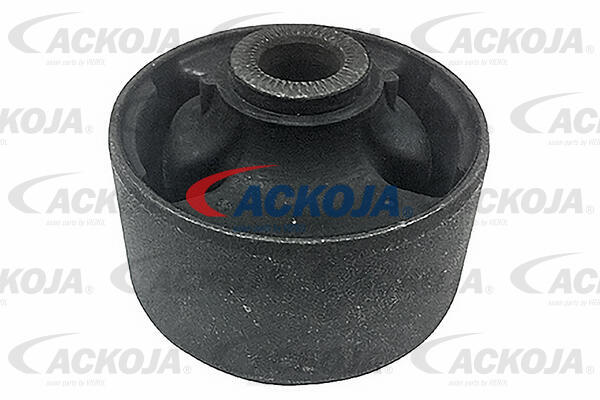
ACKOJA
ACKOJA Lagerung, Lenker A52-0214 vorne rechts links 70mm für HYUNDAI 54584A2100 54584-A6000
11.03 €
kfzteile24.de
local_shipping
6.9 €
DETAIL
DELL
Dell Precision 5570 i7-12800H 15.6" 16 GB 256 GB SSD WUXGA Bakgrundsbelyst tangentbord RTX A2000 8 GB Win 11 Pro BE
12,479.69 SEK
Refurbed.se
local_shipping
Free
DETAIL
DELL
Dell Precision 5570 i7-12800H 15.6" 8 GB 2 TB SSD WUXGA Bakgrundsbelyst tangentbord RTX A2000 8 GB Win 11 Pro CZ
16,311.5 SEK
Refurbed.se
local_shipping
Free
DETAIL
DELL
Dell Precision 7560 i9-11950H 15.6" 16 GB 1 TB SSD FHD Bakgrundsbelyst tangentbord RTX A2000 Win 11 Pro ES
15,372.51 SEK
Refurbed.se
local_shipping
Free
DETAIL
DELL
Dell Precision 7560 i9-11950H 15.6" 24 GB 2 TB SSD FHD Bakgrundsbelyst tangentbord RTX A2000 Win 11 Pro PT
16,069.16 SEK
Refurbed.se
local_shipping
Free
DETAIL
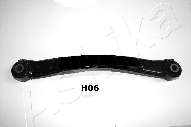
ASHIKA
ASHIKA Lenker, Radaufhängung 71-0H-H06 hinten rechts links für HYUNDAI 55100A6005 55100-A6000
47.41 €
kfzteile24.de
local_shipping
6.9 €
DETAIL
DELL
Dell Precision 5570 i7-12800H 15.6" 8 GB 128 GB SSD WUXGA Bakgrundsbelyst tangentbord RTX A2000 8 GB Win 11 Pro PT
12,933.99 SEK
Refurbed.se
local_shipping
Free
DETAIL
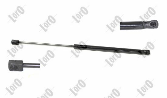
ABAKUS
ABAKUS Gasfeder, Koffer-/Laderaum 101-00-640 470N für KIA 81780A2000 81770-A2000 81780-A2000
7.22 €
kfzteile24.de
local_shipping
6.9 €
DETAIL
DELL
Dell Precision 7560 i7-11850H 15.6" 32 GB 256 GB SSD FHD RTX A3000 Webcam Win 11 Pro NL
9,404.86 SEK
Refurbed.se
local_shipping
Free
DETAIL
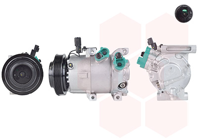
VAN WEZEL
VAN WEZEL Kompressor, Klimaanlage 8301K708 12V für KIA 97701A5200 97701-A5200
484.7 €
kfzteile24.de
local_shipping
Free
DETAIL
HERTH+BUSS JAKOPARTS
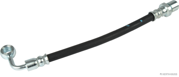
HERTH+BUSS JAKOPARTS Bremsschlauch J3707080 rechts für SUBARU 26541-AE05A 26541-AE000 26541-AE00A
16.37 €
kfzteile24.de
local_shipping
6.9 €
DETAIL
Brother
DR241 Tamburo Rigenerato per Brother HL-3140 HL-3150 HL-3170 DR 241 DR-241 DR 245 Nero e Colore Pagine 15.000 , DR 241 BK Nero Pagine 15000
9.0 €
Tonerecartucceonline.it
local_shipping
6.9 €
DETAIL
DELL
Dell Precision 5570 i7-12800H 15.6" 24 GB 1 TB SSD WUXGA Bakgrundsbelyst tangentbord RTX A2000 8 GB Win 11 Pro PL
13,610.73 SEK
Refurbed.se
local_shipping
Free
DETAIL
DELL
Dell Precision 5570 i7-12800H 15.6" 8 GB 512 GB SSD WUXGA Bakgrundsbelyst tangentbord RTX A2000 8 GB Win 11 Pro FR
12,449.41 SEK
Refurbed.se
local_shipping
Free
DETAIL
DELL
Dell Precision 7560 i9-11950H 15.6" 48 GB 2 TB SSD FHD Bakgrundsbelyst tangentbord RTX A2000 Win 11 Pro NL
17,235.4 SEK
Refurbed.se
local_shipping
Free
DETAIL
DELL
Dell Precision 5570 i7-12800H 15.6" 8 GB 128 GB SSD WUXGA Bakgrundsbelyst tangentbord RTX A2000 8 GB Win 11 Pro IT
12,933.99 SEK
Refurbed.se
local_shipping
Free
DETAIL
DELPHI
DELPHI Axialgelenk, Spurstange TA3050 vorne rechts links für SUBARU 34160-AE000 34160-AE001
15.35 €
kfzteile24.de
local_shipping
6.9 €
DETAIL
chevron_left
116
117
118
119
120
121
122
123
124
125
chevron_right